| Year | Arab | Total |
|---|---|---|
| 1931 | 81 | |
| 1944/45 | 230 | 230 |
| Year | Arab | Jewish | Public | Total |
|---|---|---|---|---|
| 1944/45 | 7846 | 1949 | 9795 |
| Use | Arab | Jewish | Total | ||||||||
|---|---|---|---|---|---|---|---|---|---|---|---|
|
1446 | 1446 (15%) | |||||||||
|
6400 | 1949 | 8349 (85%) |
The village, which stood on an elongated hill that ran from east to west, overlooked Wadi Ara (the wadi after which it was named) to the north. There was another broad wadi to the south of the village. The village site was strategically valuable because it controlled the western gateway of Wadi Ara, which connected the coastal plain with the plain of Marj ibn Amir. The village of Wadi Ara was also close to the Hadera-Afula highway, which ran southwest-northeast and intersected the Haifa-Jenin highway about 13 km to the northeast. Yet another road passed near the wadi, leading west to the coastal highway. The Muslim geographer Ibn Khurdadhbi (d. A.D. 912) described it as a stopping place between al-Lajjun and Qalansuwa. ![]() The village of Wadi Ara was classified as a hamlet by the Palestine Index Gazetteer. Its overall plan was square, and its houses were made of masonry. The village's population was Muslim. Agriculture and animal husbandry constituted the backbone of its economy. In 1944/45 a total of 6,400 dunums was allotted to cereals. The archaeological site of Tall al-Asawir, a low mound occupying thirty dunums of land, lay to the northwest. It was excavated in 1953 and was found to contain burial caves dating from the fourth to the second millenium B.C.
The village of Wadi Ara was classified as a hamlet by the Palestine Index Gazetteer. Its overall plan was square, and its houses were made of masonry. The village's population was Muslim. Agriculture and animal husbandry constituted the backbone of its economy. In 1944/45 a total of 6,400 dunums was allotted to cereals. The archaeological site of Tall al-Asawir, a low mound occupying thirty dunums of land, lay to the northwest. It was excavated in 1953 and was found to contain burial caves dating from the fourth to the second millenium B.C.
Israeli historian Benny Morris says that the villagers, fearing an Israeli attack, fled as early as 27 February 1948. If so, this was the earliest flight in the whole area. Morris does not indicate what precipitated the evacuation. However, an Arab source provides the probable cause. The records of Arab Liberation Army (ALA) commander Fawzi al-Qawuqji indicate that a Jewish force from the settlement of Ma'anit attacked Palestinian villagers in the area of Wadi Ara during the night of 27-28 February 1948. The ALA dispatched a company to defend them which engaged the Haganah force at dawn, and might have reached the Jewish settlement were it not for the intervention of a British force. One casualty was reported among the villagers, three among the ALA, and twenty-five among the Haganah.
The area was also the scene of 'heavy fighting' in later months, and Qawuqji reported on 8 May that 'our forces have been engaging enemy forces in the Ara area.' The following day, a Haganah force including a number of armored cars set off from the settlement of En ha-Shofet and penetrated as far as Ara, but the ALA detachments 'resisted and repelled this attack and forced the enemy to retreat....' It is not clear when the village was eventually occupied, but at the end of the war, it lay close to the armistice lines drawn between Jordanian- and Israeli-held territory in 1949. As part of the armistice agreement of 3 April 1949, relatively large areas of land in the Wadi Ara region were ceded under duress to Israel. These may have included lands belonging to the village. Some of the inhabitants of this region remained in their villages at least until July 1949, for Morris makes a reference to 'the Wadi Ara villages' that stayed put and could not be expelled by Israel because of international political considerations. ![]()
'En Iron was built in 1934 on what were traditionally village lands. Ma'anit, founded in 1942, is just south of the site it is not on village land. Kibbutz Barqay was established on the village site on 10 May 1949.
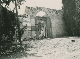
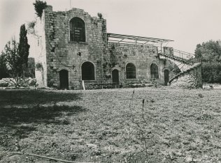
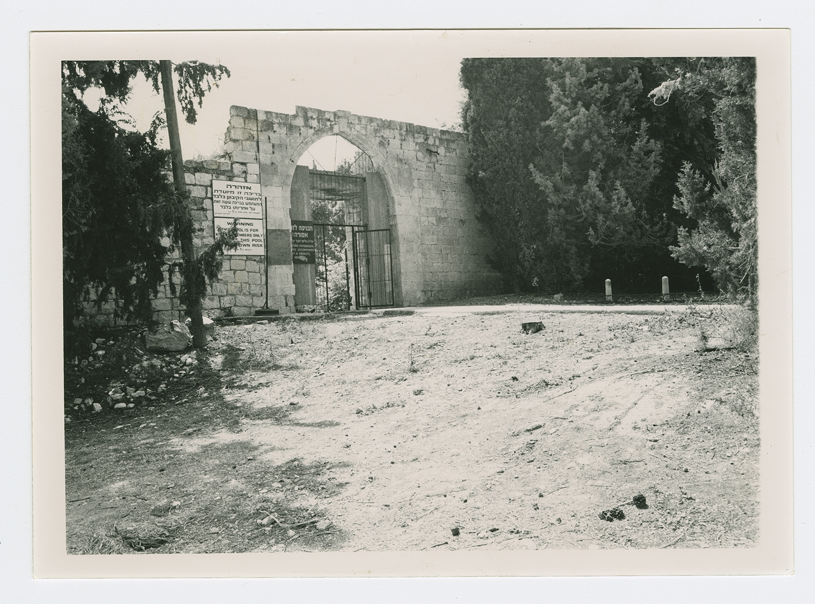
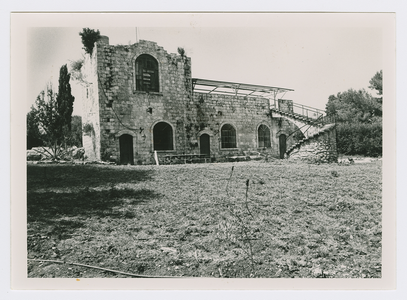
The site is occupied by Kibbutz Barqay. Only two village houses remain, both on the eastern edge of the site. One of them has arched windows and a spiral staircase leading up to a room on the roof. The second has a large entrance that is used today as a gate for the kibbutz's swimming pool. Fig trees and cactuses are scattered east of the houses.